Friendly Note: FreeJupiter.com shares general info for curious minds 🌟 Please fact-check all claims—and always check health matters with a professional 💙
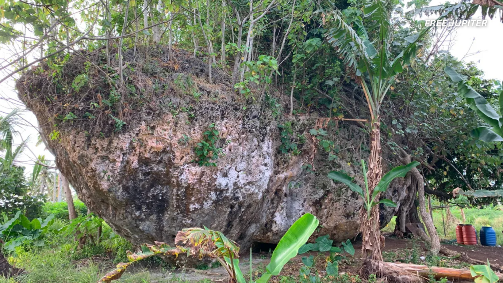
In the lush southern reaches of Tongatapu, a colossal limestone boulder quietly rests, largely unnoticed by the local community. This massive stone, known by the name Maka Lahi—meaning “Big Rock” in the Tongan language—has recently been identified by geologists as the heaviest cliff-top boulder ever documented worldwide. Its presence far inland and perched high above sea level serves as a compelling testament to an extraordinary natural event: a powerful tsunami that struck Tonga roughly 7,000 years ago.
Discovery of an Enormous Boulder
The discovery of Maka Lahi was somewhat serendipitous. Martin Köhler, a doctoral researcher from the University of Queensland, was conducting a survey along the southern coastal cliffs of Tongatapu, searching for geological traces of ancient tsunamis. One afternoon, local farmers directed him toward an overgrown hill located more than 200 meters from the ocean’s edge. There, amidst dense vegetation, lay the enormous boulder.
Köhler expressed his astonishment at the find, noting that the boulder’s inland location placed it well outside the team’s planned fieldwork area. The sheer size and position of the rock suggested it had been transported there by an exceptionally large tsunami. “It was quite unbelievable to see this big piece of rock sitting there covered in and surrounded by vegetation,” he remarked.
Measuring the Giant
Employing drone technology and laser scanning, Köhler’s team created a detailed three-dimensional model of the boulder. The measurements revealed a rock approximately 14 meters in length, 12 meters in width, and nearly 7 meters in height. Based on these dimensions, the researchers estimated the boulder’s weight at around 1,180 metric tons—heavier than three fully loaded Boeing 747 airplanes combined.
Chemical analysis of the limestone confirmed that the boulder originated from coral reef limestone typical of the nearby coastline. The team pinpointed its original resting place to a cliff over 30 meters above the current sea level, indicating that the boulder had been dislodged and carried inland by a forceful wave.
Unraveling the Power Behind the Movement
The question naturally arises: what kind of natural event could shift such a gargantuan rock so far from its source? To explore this, the researchers conducted numerical wave-flume experiments simulating different wave scenarios. Their findings showed that even the most intense storms, including Category 5 cyclones, lack the strength to move such a massive object.
The only plausible explanation was a tsunami generated by a submarine landslide, producing a single, towering wave approximately 50 meters high that lasted for about 90 seconds. This monstrous wave would have struck with enough force to break the boulder free from its cliff ledge, propel it inland at speeds exceeding 20 meters per second, and deposit it at its current elevation 39 meters above sea level.
Dating the Event: A Glimpse into the Holocene
To determine when this colossal event occurred, the team used uranium-thorium dating on flowstone formations found on the boulder’s shaded surfaces. The results dated the tsunami to roughly 6,900 years ago, placing it in the early Holocene epoch—a period that began around 11,700 years ago marked by significant climatic and sea-level changes.
Co-author Annie Lau, a coastal geomorphologist at the University of Queensland, underscored the importance of understanding such ancient events. She noted that Tonga’s recent tsunami in 2022, which tragically resulted in fatalities and widespread damage, highlights the necessity of studying past extreme events to better prepare for future hazards.
Read more: 23-Year-Old Ukranian Discovers Way To Make Paper From Fallen Leaves Without Cutting Down Trees
The Broader Implications: Tsunamis and Coastal Hazards
This discovery enriches scientific knowledge about how powerful waves can transport enormous rocks, providing valuable data for improving hazard assessments in tsunami-prone regions worldwide. Radiocarbon evidence suggests that the tsunami responsible for moving Maka Lahi may have been triggered by a massive underwater landslide or volcanic flank collapse along the nearby Tofua volcanic arc—geological processes that remain active today.
The 2022 eruption of Hunga Tonga, which generated tsunami waves nearly 20 meters high, serves as a modern reminder of the region’s volcanic volatility. The Maka Lahi boulder, however, indicates that the area is capable of producing waves more than twice that height.
Cultural Echoes: Folklore Meets Geology
Interestingly, local Tongan legends speak of the demigod Māui, who is said to have thrown rocks across the sea while chasing birds. These stories may preserve cultural memories of ancient tsunami events, now being substantiated through scientific investigation. Another significant boulder, known as Maui Rock, located on Tongatapu’s western shore, is believed to have been displaced by a tsunami in the 15th century.
Together, Maka Lahi and Maui Rock frame a narrative of Tonga’s history punctuated by rare yet devastating waves.
Preparing for the Future: Lessons from the Past
Most inhabitants of Tongatapu live on the coastal plain, with current evacuation plans designed around tsunami waves reaching up to 20 meters. However, a wave of 50 meters, as suggested by the Maka Lahi event, would surpass these safety zones and threaten the capital city, Nuku‘alofa.
Updating hazard models to incorporate such low-probability but high-impact events is crucial. While early-warning systems can detect tsunamis generated by earthquakes within minutes, waves triggered by submarine landslides offer little lead time, underscoring the need for ongoing public education and clearly marked evacuation routes.
Environmental and Global Significance
As sea levels continue to rise due to climate change, the reach of future tsunamis could extend even further inland. The Maka Lahi boulder’s movement occurred when sea levels were comparable to today’s, suggesting that similar or larger events in the future may have even more extensive impacts.
Additionally, climate change-driven coastal erosion and increased landslide activity could raise the frequency of such extreme waves. Beyond Tonga, massive cliff-top boulders have been documented along coastlines in regions such as the Mediterranean and the Caribbean, but few have undergone the detailed dating and modeling applied to Maka Lahi. Its exceptional size, elevation, and inland location make it a critical benchmark for refining global tsunami models.
Read more: Japan Shatters The Internet Speed Barrier – With Speeds of 402 TBPS Over Regular Fiber
A Monument to Oceanic Fury
Standing beside this limestone giant, one cannot help but reflect on the immense natural forces that shaped its journey. Köhler recalled how the team’s 3D modeling led them to identify the boulder’s original cliff perch over 30 meters above sea level, revealing a long-forgotten chapter of oceanic power.
Maka Lahi is more than just a rock; it is a silent witness to a past when the sea unleashed a colossal surge capable of reshaping the landscape. Understanding this history is not merely an academic pursuit but a vital step toward safeguarding communities against the next monumental wave.
The comprehensive study detailing these findings has been published in the journal Marine Geology, marking a significant contribution to the fields of geology, coastal hazard assessment, and disaster preparedness.